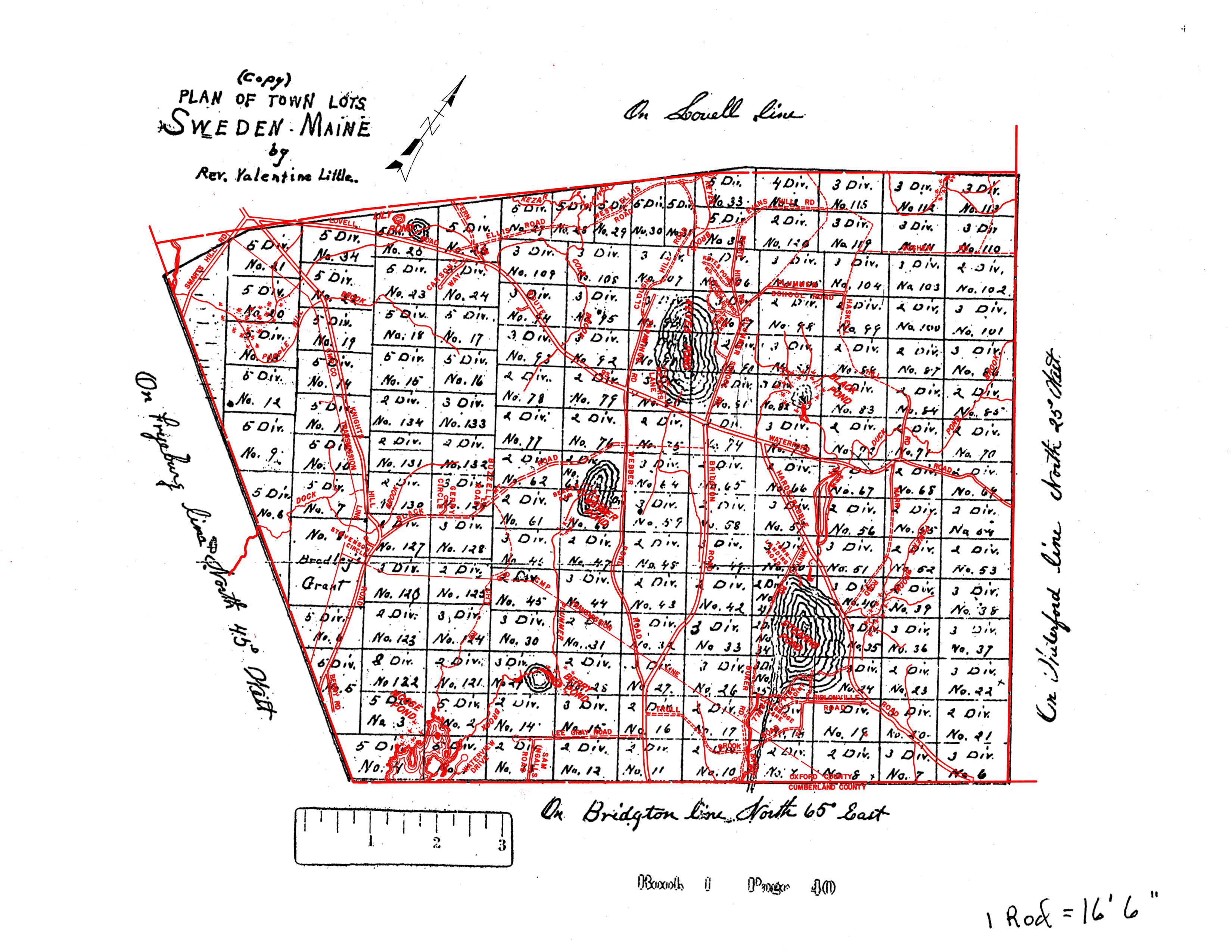
| About the Proprietors Map from Marcia Storkerson |
The descendants of the men who fought with Captain John Lovewell were
granted land by Massachusetts for their service. Erroneously,
Massachusetts originally granted land in an area over which it had no
jurisdiction: New Hampshire (called Suncook). The error was rectified
with their ultimate grant located in what is now Lovell and Sweden,
known as New Suncook. The Lovell
Historical Society (LHS) has a copy of a map by Joseph Frye from
December 24, 1740 entitled: “A Plan of the Township of the contents of
seven miles square granted to the proprietors of Suncook.” The above described messy beginning took at least one generation to be accomplished, so the prime movers in the settlement of the town of New Suncook were descendants of the original grantees. The heirs of the original grantees surveyed the New Suncook land and managed its division into primarily 100-acre lots, managed their sale, and collected taxes. The division of the lots had five or six iterations moving out from now Lovell Village. Sweden was often referred to as the “Four Mile Square”. There are many versions of so-called “Proprietors Maps” in the LHS collection which, oddly enough, does not have one drawn by Rev. Valentine Little. Rev. Little may only have drawn one of the Town of Sweden. I have seen a few of the LHS proprietors maps. The most commonly referenced one was done by Waldo N. Seavey, dated April 1, 1943, which contains the following note: I
made this plan after a careful study of old plans such as Blake,
Nevers, Woods, Webber and U.S.G.S. by checking them with the field
notes and records of Solomon Heald, Preston W. Charles, C.E. Hobbs and
my own.” Rev. Valentine Little (1790-1852) was born and died in Salisbury, N.H. According to what I could find at LHS on-line, he went to Salisbury Academy and Dartmouth College. I assume in the following order, he:
Rev. Little lived in a house on Hatch Hill in Lovell. He also owned land (probably a wood lot) on Black Mountain in Sweden near the recent subdivision on the north side of Black Mountain Road toward the Knights Hill Road end. Rev. Little’s motivation for drawing (probably redrawing) a map of the proprietors lots in Sweden is not known. Added: A reference to Valentine Little linking him to surveying may be found in the biography of Thomas Dearborn Little ("The History of Merrimack and Belknap Counties, New Hampshire". Edited by D. Hamilton Hurd and Published in 1885): “Having a
liking for mathematical studies, he [Thomas Dearborn] studied surveying
with his uncle, Rev. Valentine Little, and assisted in the preliminary
survey and location of the Northern New Hampshire Railroad, in 1845.”
|
| Sweden Historical Society |